
")


One expert says the storm could be seen hours before and the risk should have been communicated, even in the middle of the night.
A superyacht that sank off the coast of Sicily was likely struck by a waterspout made stronger by climate change, meteorologists have said.
Waterspouts are whirling columns of air and water mist, and the Bayesian is believed to have been hit by a powerful one in the early hours of Monday morning.
Three people, including Canadian-Antiguan chef Recaldo Thomas, are confirmed to have died. Two bodies were recovered from the wreck this afternoon, and four people remain missing, including British tech entrepreneur Mike Lynch and his 18-year-old daughter, Hannah.
The boat is at a depth of 50m and is therefore very challenging to access even with a crew of expert divers. Hopes are fading of finding any survivors.
Questions remain over how the incident occurred, but climate scientists have pointed to the role that record Mediterranean sea temperatures played in fuelling the freak storm.
What are waterspouts?
These dangerous sea twisters fall into two categories, according to the US National Ocean Service (NOS): fair weather waterspouts and tornadic waterspouts.
The Bayesian is thought to have been hit by the latter. These are tornadoes that form over water, or move from land to water, and have the same characteristics as a land tornado.
They develop downward in a thunderstorm and are “often accompanied by high winds and seas, large hail, and frequent dangerous lightning,” NOS says.
Fair weather waterspouts, by contrast, develop on the surface of the water and work their way upward. They form in light wind conditions so tend to move very little.
Witnesses have described seeing a waterspout form off the coast of Porticello, near Palermo in western Sicily, where the 56-metre Bayesian was moored. It reportedly lasted just a few minutes.
The Bayesian could have been struck by a ‘downburst’
Until we see definite proof like eyewitness reports or video recordings, there remains some doubt that a waterspout caused the yacht to capsize.
Lars Lowinski, a meteorologist at Weather & Radar, says another possibility is very strong gusts of wind called a downburst: cool air rushing down from the storm cloud and spreading out near the surface.
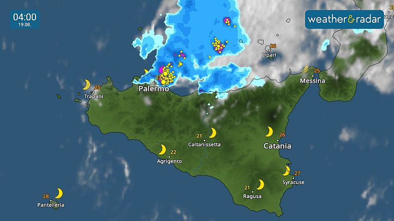
The weather service’s map shows a blob of intense thunderstorm activity just east and northeast of Palermo at 4am on 19 August, indicating a severe storm moving across the sea.
“While the intense, rotating winds of [a waterspout] can result in severe damage, they do not necessarily produce large waves and chaotic seas since they are a small-scale phenomenon. There are witness reports mentioning large waves, which would rather suggest that a downburst may have caused this,” Lowinski tells Euronews Green.
Downbursts can be bigger and generate very large waves in a short amount of time, he adds. “A downburst can easily generate winds above 150km/h which is enough to create huge difficulties for a yacht like this.”
Is climate change making storms and waterspouts worse?
The Mediterranean is much warmer than usual due to several weeks of abnormally hot weather.
Last week, the sea’s surface temperature hit a record high of 28.9C, according to Spanish researchers. Around Sicily, the sea surface hovered between 27.3C and 30.5C on Monday.
This thermal energy makes storms more intense, Luca Mercalli, president of the Italian Meteorological Society, told the UK’s Guardian newspaper.
“30 years ago an event of this kind might have brought winds of 100kmh,” he said. “Today it’s 150kmh because sea temperatures of three degrees higher means an enormous quantity of energy for storms, and when cold air arrives it’s explosive.”
Like other Mediterranean countries, Italy has been baking under heatwaves for the past two months. Its most recent spell of extreme heat was broken last weekend by a sudden blast of cold air and heavy storms.
“Warmer seas also lead to more moisture in the air which is the fuel for severe storms,” says Lowinski.
“The main season for intense thunderstorms in the Med is typically between late August and late October to early November. This is because low pressure systems and cooler upper-level air will become more frequent later in the year, while the sea is still very warm from the long, hot summer,” he explains.
“That creates the energy mix for severe weather, including thunderstorms, hail, high winds and waterspouts.”
Waterspouts are more common than you might think, notes the BBC’s weather presenter Matt Taylor. According to the International Centre for Waterspout Research, there were 18 confirmed waterspouts off the coast of Italy on 19 August (the day the yacht capsized) alone.
With sea temperatures continuing to rise in line with greenhouse gas emissions, experts say these extreme events could become more common.
However, Lowinski cautions, “individual events such as this one on 19 August have happened before, even without climate change. It is therefore hard to make a direct link between this disaster and climate change.”
Storm warning system fell short, meteorologist says
Lowinski, who also specialises in weather warning communication, says that safety should also be in the spotlight.
“This particular storm system could already be seen about three hours before the disaster happened, far to the NW of Sicily,” he tells Euronews Green.
“While local-scale severe weather, waterspouts, downbursts, etc. are always challenging to pinpoint and forecast, the risk was there and should have been communicated through all necessary channels, even in the middle of the night (which is when many people are asleep and unaware of approaching danger).”
According to Italian newspaper la Repubblica, the two bodies recovered from the wreck this afternoon were seen behind two mattresses.


